Unlike outdoor navigation that enjoys the power of GPS, an indoor navigation system has to tackle complex, GPS-denied environments like malls, airports, offices, and hospitals. This blog explores the world of indoor navigation, shedding light on the cutting-edge technology that makes it possible, and the potential it holds for transforming our interactions within indoor spaces.
What is Indoor Navigation?
Indoor navigation is the technology that helps users locate the best route to a destination within indoor environments. The primary components of indoor navigation include accurate indoor positioning to ascertain a user’s current location, digital mapping to represent the indoor spaces, and route guidance algorithms that generate and communicate the ideal path to the intended destination. These elements work together to facilitate efficient and user-friendly navigation. They are indispensable inside complex structures where GPS signals are unavailable or unreliable.
Differences Between Indoor & Outdoor Navigation
GPS-based outdoor navigation relies on satellite signals and is ideal for open environments. But these signals lose precision and strength indoors, making them unsuitable for accurate indoor positioning. Indoor navigation systems overcome these limitations by utilizing alternative technologies such as Wi-Fi, Bluetooth beacons, ultra-wideband, and inertial sensors. They triangulate position within buildings where GPS is unreliable. These technologies allow navigation solutions to deliver precise location data, necessary for effective guidance and mapping in complex indoor spaces.
Key Concepts in Indoor Navigation
Indoor Positioning System (IPS)
An Indoor Positioning System (IPS) is a technological framework designed to locate and track objects or individuals within indoor environments. These can include shopping malls, hospitals, and office buildings, where GPS is ineffective. It utilizes various technologies, including Wi-Fi, Bluetooth Low Energy (BLE), and Ultra-Wideband (UWB), to accurately pinpoint locations. These technologies enable the IPS to provide precise location data essential for indoor navigation.
Indoor Mapping
Indoor mapping involves creating digital representations of indoor environments to facilitate navigation, wayfinding, and space management. This process generates maps that include key elements such as points of interest (POIs) like exits, restrooms, and stores, along with the overall floor layout, encompassing corridors, rooms, and elevators. These maps are crucial for improving wayfinding accuracy and enhancing user experience.
Turn-by-Turn Directions
Turn-by-turn directions is a critical feature offering step-by-step guidance to users navigating through complex indoor spaces. It is essential for providing clear, real-time directions, which helps to reduce confusion and save time in intricate environments. This ensures that visitors find their destinations without getting lost, by delivering accurate and timely instructions as well as turn-by-turn directions.
Dynamic Wayfinding
Dynamic wayfinding is a sophisticated feature that updates routes in real time. It adapts to changes in the user’s location and the environment. Dynamic wayfinding provides the most efficient and current route, taking into account congestion or closed paths, as the user moves. This real-time responsiveness ensures that users are guided accurately and efficiently.
Types of Indoor Navigation Technology
Bluetooth Beacons
Beacons are small wireless transmitters that use Bluetooth Low Energy (BLE) to determine a user’s position within an indoor space. They allow location to be accurately pinpointed by measuring signal strength and using algorithms for triangulation. Due to their low cost and ease of deployment, Bluetooth beacons are particularly suitable for scalable indoor positioning solutions.
Wi-Fi-Based Positioning
Wi-Fi positioning leverages the existing Wi-Fi infrastructure to estimate a user’s location. It does this by analyzing the strength of the Wi-Fi signals received by the user’s device from multiple access points. This approach is particularly advantageous in large facilities where Wi-Fi networks are prevalent and can be used without additional hardware. It provides a cost-effective method for indoor localization and navigation.
Ultra-Wideband (UWB) Positioning
Ultra-wideband (UWB) positioning is a state-of-the-art technology known for its high accuracy and short-range capabilities. It is ideal for navigation and real-time asset tracking. UWB operates by measuring the time it takes for radio waves to travel between UWB devices, thereby determining precise locations. Due to its pinpoint accuracy, UWB is particularly useful in environments where exact tracking is critical. Specifically healthcare, for monitoring patient movements or in manufacturing for locating equipment and optimizing workflows.
Applications of Indoor Navigation
Indoor Navigation in Healthcare
In hospitals, navigation systems guide patients and visitors through complex layouts, to specific departments or patient rooms. This system significantly reduces confusion and anxiety that often accompanies navigating large medical facilities. This enables faster access to essential services and improves the overall visitor experience. It ensures that individuals can arrive at their destinations more efficiently, enhancing operational flow and avoiding missed or late appointments.
Indoor Navigation in Retail
In retail stores and shopping malls, indoor navigation guides customers to specific departments, products, or promotions with ease. It is common for navigation to be delivered through the mobile app of the store. This technology not only improves customer satisfaction by making shopping more convenient and personalized, but also increases store efficiency. By streamlining the path to purchase, retailers can effectively manage foot traffic and highlight promotions or discounts. This encourages higher sales and a more engaging shopping environment.
Indoor Navigation in Workplaces
In corporate offices navigation optimizes efficiency by assisting employees to swiftly locate meeting rooms, desks, resources, or shared facilities. By easing the process of finding POIs, it minimizes disruptions and saves time, which is particularly beneficial in a hybrid work environment. The technology supports flexible and hybrid work models by enabling employees, who may not be in the office daily, to navigate shared spaces effectively and integrate seamlessly on the days they are present.
Indoor Navigation in Transportation Hubs
Indoor navigation plays a critical role in airports, train stations, and other transportation hubs by guiding travelers efficiently to their gates, lounges, and various amenities amidst the bustling and often complex layouts. This technology streamlines the travel process, mitigating stress and confusion, and ensures that passengers can find their way through intricate spaces with ease. By providing clear, real-time directions, indoor navigation significantly contributes to a seamless and more enjoyable travel experience. This allows passengers to navigate these hubs without the fear of getting lost.
Benefits of Indoor Navigation Systems
Enhanced User Experience & Accessibility
Indoor navigation systems provide users with clear, step-by-step guidance to specific locations within a building, effectively reducing confusion and stress that can arise from navigating unfamiliar environments. The directions and visual maps greatly enhance accessibility for new or infrequent visitors and those who are not acquainted with the facility’s layout. By simplifying the wayfinding process, indoor navigation ensures that all users can reach their desired destinations smoothly and with greater confidence.
Increased Operational Efficiency
Indoor navigation systems optimize space and resource utilization by providing data insights and management tools that help organizations effectively manage their facilities. By directing foot traffic efficiently and avoiding bottlenecks, these systems lead to reduced traffic congestion within the premises, ensuring smoother facility operations. The ability to monitor and influence the flow of people and the use of spaces in real-time, allows for a significant improvement in the overall efficiency and functionality of a facility, facilitating a better allocation of resources and space management.
Data-Driven Insights & Analytics
Indoor navigation systems collect and analyze data on the usage of various spaces within a facility. This offers valuable insights to facility managers. This data enables more informed decision-making regarding layout adjustments and optimal resource allocation. By understanding patterns of space usage, managers can plan more effectively, ensuring that the layout of the facility meets the evolving needs of its users and enhances overall operational efficiency.
Cost Savings & ROI
Indoor navigation systems contribute towards reducing operational costs by improving space utilization and decreasing the need for extensive physical signage. Enhanced use of space and guided digital directions facilitate more efficient facility management, minimizing waste and lowering overheads. This optimization also leads to a higher Return On Investment (ROI) for businesses, as they can leverage precise navigation aids to streamline facility operations and enhance user experience.
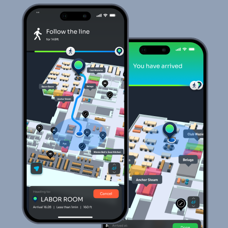
How Cisco Spaces’ Indoor Navigation Can Improve Visitor & Employee Experiences
Cisco Spaces’ Indoor Navigation sets a new standard for navigating complex facilities by offering app-free, turn-by-turn, blue-dot navigation on AI-powered 3D maps. Accessible by merely scanning a QR code on a mobile device, this advanced solution eliminates the need for users to download an app, making the whole experience seamless and incredibly user-friendly. With Cisco Spaces, businesses can significantly enhance the way individuals move through their buildings, ensuring visitors and employees alike can find their way effortlessly. The technology includes a sophisticated feature for converting CAD files into AI-powered 3D maps, making deployment of indoor navigation an effortless process. The best part is that all of this is achieved using existing Cisco infrastructure, at a significantly low total cost of ownership. This efficient and cost-effective approach allows for quick adoption without the need for extensive modification or additional hardware.
Explore Cisco Spaces’ Indoor Navigation to streamline movement within spaces and improve user experiences.